WELCOME TO HA GIANG
🌄 WELCOME TO HA GIANG – THE GEM OF VIETNAM’S NORTHERNMOST REGION 🇻🇳
Located at the northernmost point of Vietnam and bordering China, Ha Giang is home to many ethnic minority groups living on majestic limestone plateaus over 1,000 meters high. 🏞️
Each ethnic group in Ha Giang has its own unique traditions and customs, creating a rich and diverse cultural mosaic. Since most locals rely on agriculture, the environment here remains largely untouched—pure, pristine, and peaceful. 🌿🌾
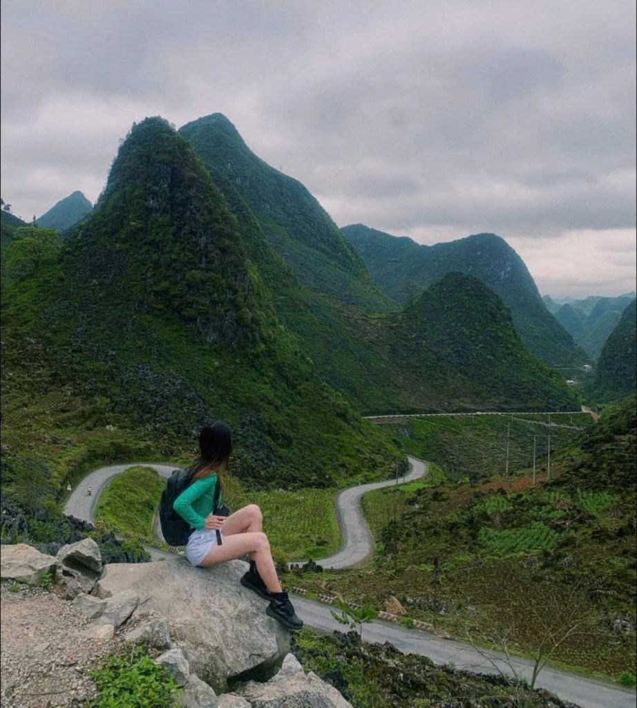
🛣️ The Ha Giang Loop, stretching 375 km, is a must-do journey. The winding road takes you through towering mountain ranges, enchanting valleys, and remote villages perched on rocky hillsides.
Along the way, travelers will encounter locals dressed in vibrant traditional clothing 🌈, cheerful children playing along the roadside 👧👦, and hardworking farmers tending to their stunning terraced rice fields 🌾🧺.
Ha Giang is not just a destination—it’s a journey back to the raw beauty of nature and the authentic culture of Vietnam’s northern highlands. ✨

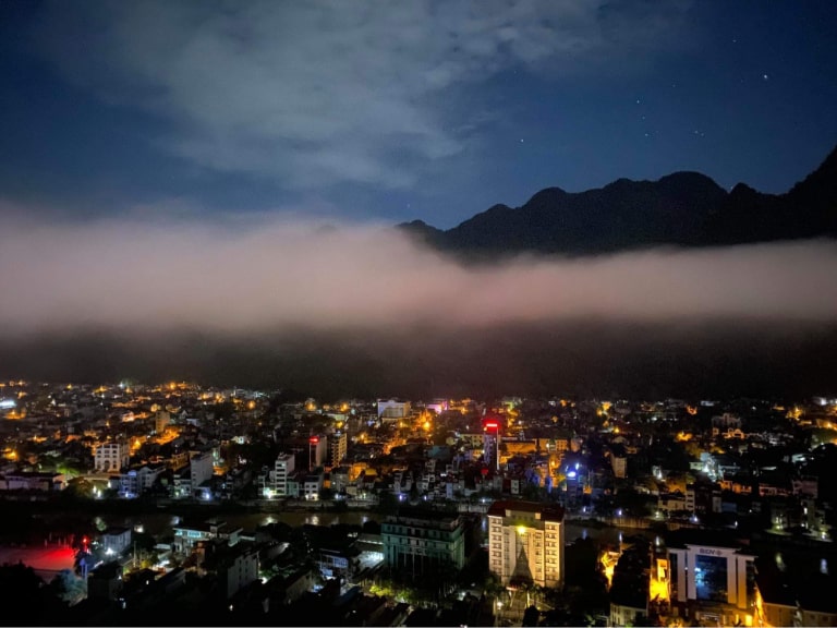
🏙️ HA GIANG CITY – THE HEART OF VIETNAM’S NORTHERNMOST REGION
As the political, economic, cultural, and social center of Ha Giang province, Ha Giang City takes pride in its remarkable growth, rising steadily from a once-young town into a vibrant urban hub. 🌟
📍 Nestled on both sides of the poetic Lo River, the city is lined with modern high-rise buildings standing close together, reflecting a dynamic and evolving skyline. Key inner-city streets like Nguyen Trai, Tran Phu, and Tran Hung Dao are paved with smooth asphalt, offering convenience and accessibility. 🛣️
🏞️ On the east bank of the Lo River stands Neo Mountain, while Cam Son Mountain rises on the west bank—two majestic peaks that mirror each other like twin towers reaching toward the blue sky. ⛰️🌄
🌆 Ha Giang City is not only the ideal starting point for exploring the Dong Van Karst Plateau or the legendary Happiness Road, but also a place where modernity meets tradition—where breathtaking nature harmonizes with the rich cultural heritage of Vietnam’s northern highlands. ✨
🌀 BAC SUM PASS – THE GATEWAY TO THE HA GIANG LOOP ⛰️
As you begin your adventure along the Ha Giang Loop, don’t miss the breathtaking Bac Sum Pass – a scenic mountain slope that connects Vi Xuyen District to Quan Ba District. 🚗🌄
This pass winds gracefully around the base of a twin mountain, and from above, the road resembles a giant snake slithering through the lush green mountains of Ha Giang. 🐍🌿
Each sharp curve presents a thrilling challenge to travelers, but the reward lies in the journey itself. 🧭 The higher you climb, the more spectacular and panoramic views open up before your eyes – an awe-inspiring gift of nature. 🎁👀
📸 Bac Sum Pass is not only a highlight for photography lovers, but also the perfect start to the majestic landscapes that await deeper into the northern highlands.
🌤️ QUAN BA HEAVEN’S GATE – THE FIRST WINDOW TO THE SKY OF HA GIANG 🏔️
On your journey along the legendary Ha Giang Loop, make sure to stop at Quan Ba Heaven’s Gate – a stunning mountain pass that marks the gateway from Vi Xuyen to Quan Ba District. 🚵♂️🌿
This scenic route winds its way around the foot of the famous Twin Mountains (Fairy Bosom), and from a bird’s eye view, the road resembles a giant serpent curling through the emerald hills of Ha Giang. 🐍💚
Each twist and turn of Bac Sum Pass, leading up to Heaven’s Gate, challenges your courage and rewards you with breathtaking panoramas. 📸 The higher you ascend, the more the majestic landscape opens up – clouds drifting across rugged peaks, deep valleys below, and endless layers of mountain ranges blending into the horizon. 🌄⛰️
Standing at Quan Ba Heaven’s Gate, you’ll feel as if you’re touching the sky – a moment of serenity, awe, and connection with the wild beauty of northern Vietnam. ✨

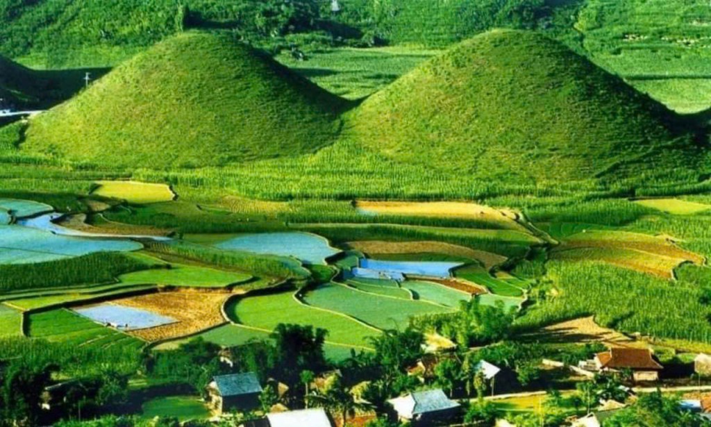
⛰️ QUAN BA TWIN MOUNTAINS – THE FAIRY’S BREASTS OF HA GIANG 🌸
Located in Quan Ba District, the Quan Ba Twin Mountains—also known as the Fairy Bosom Mountains or Co Tien Mountains—are one of the most iconic natural landmarks of the Ha Giang Loop. 🏔️✨
Formed approximately 1.6 to 2 million years ago, this rare geological wonder features two perfectly rounded hills, standing side by side in a lush valley surrounded by towering karst mountains. 🌿🌺
From a distance, the two hills resemble the gentle, curving shape of a fairy’s breasts, as if a celestial maiden were peacefully sleeping amidst the grandeur of the forested highlands. 🌌💤
The unique beauty and mystique of the Twin Mountains have inspired legends, songs, and countless photos, making it a must-see stop on any journey through Ha Giang. 📷🏞️
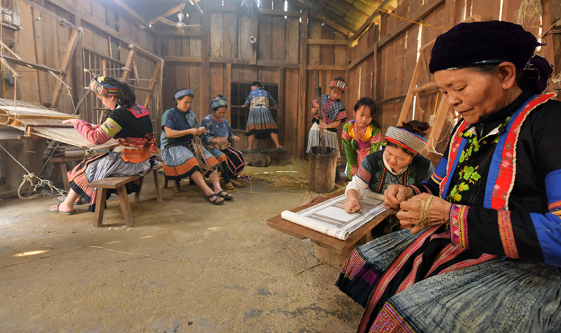
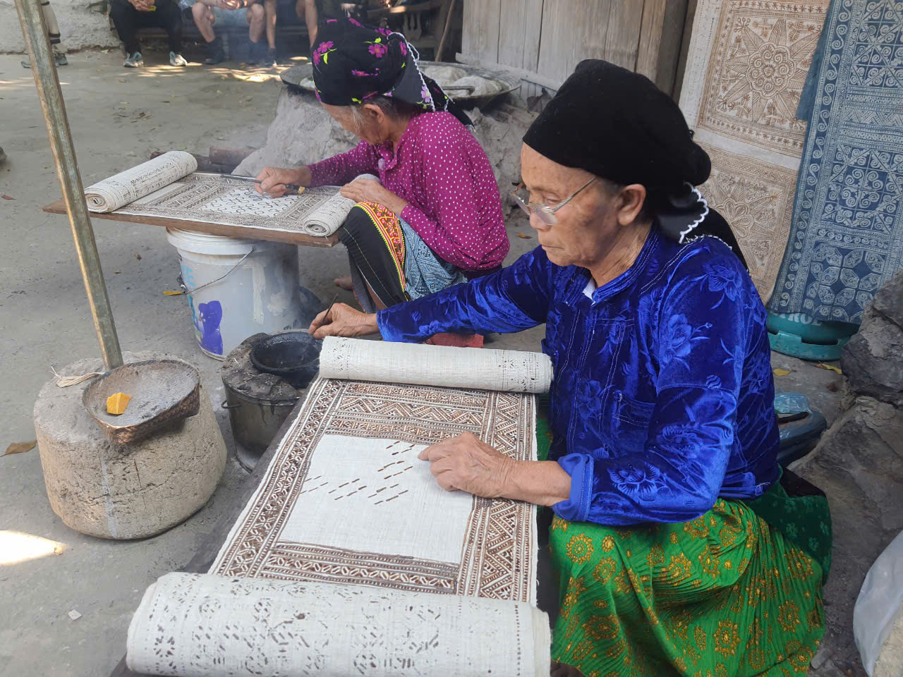
🧵 LUNG TAM LINEN – THE LIVING HERITAGE OF THE H’MONG PEOPLE IN HA GIANG 🌿
In the heart of the Dong Van Karst Plateau, the brocade and linen products crafted by the H’Mong people are a stunning showcase of tradition, patience, and artistry. 🏔️👗
To create the exquisite outfits worn during Tet holidays and major cultural festivals, H’Mong women dedicate an entire year to a meticulous process that includes 41 complex stages—from growing and harvesting flax, peeling and pounding the fibers, spinning the yarn, boiling and softening it, to eventually setting up the loom and weaving. 🪢🧶
Each step demands skill, care, and a deep love for the craft. “To make a beautiful piece of fabric, the artisan must truly love her work, be persistent, and masterful with her hands.” 💬💖
In Lung Tam village, this traditional linen weaving is more than a craft—it is a symbol of cultural pride and resilience. The finished products, with their intricate and meaningful patterns, serve as vibrant proof of the industrious spirit and endurance of the H’Mong people. ✨💪
Visiting Lung Tam is not only an opportunity to witness authentic craftsmanship, but also to support the preservation of Vietnam’s intangible cultural heritage. 🧵🌏
🌲 YEN MINH PINE FOREST – A SERENE ESCAPE IN THE HEART OF HA GIANG 🏞️
On the journey from Ha Giang City toward the northern highlands, travelers pass through the enchanting Yen Minh Pine Forest—a peaceful stop nestled among the mountains, perfect for a relaxing break after hours on the winding road. 🚗🌄
Stretching over gentle hills, Yen Minh Pine Forest is often described as the “mountain girl of Ha Giang”—quiet, graceful, and full of natural charm. 🌿🌸
As you step beneath the tall, whispering pines, you’ll feel the cool breeze carry away your fatigue. It’s a place where the soul meets nature in perfect harmony, offering moments of peace and reflection amid the wild beauty of Vietnam’s northern mountains. 🌬️💚
Whether you’re stopping for a quick breath of fresh air or staying to capture the perfect photo, Yen Minh Pine Forest is a must-visit highlight on the Ha Giang Loop. 📸🌲

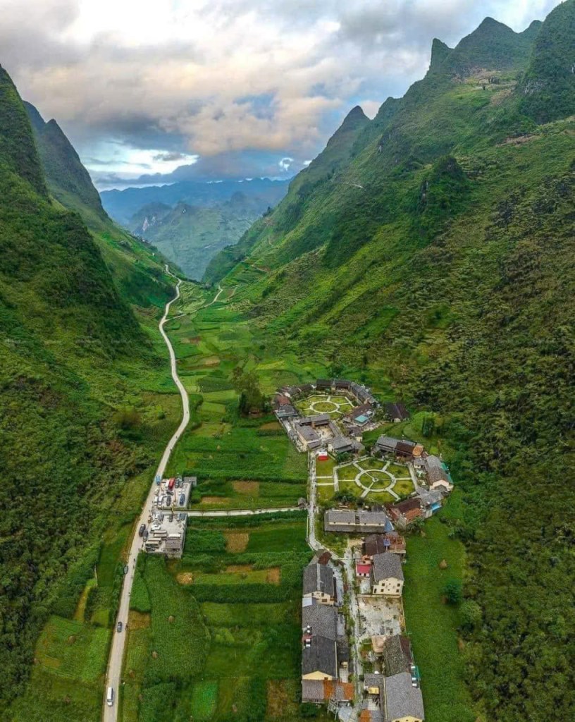
🏡 NAM DAM VILLAGE – A PEACEFUL DAO COMMUNITY IN THE HEART OF HA GIANG 🌿
Located in Quan Ba District, about 45 km from Ha Giang City, Nam Dam Village has been chosen as a model for community-based cultural tourism thanks to its stunning natural scenery and the local Dao ethnic group’s strong commitment to preserving their traditional heritage. 🧣🌾
Nestled at the foot of the iconic Twin Mountains—a symbol of Ha Giang tourism—Nam Dam offers a serene and authentic experience just 8 km from Quan Ba Heaven’s Gate, right on the route to Yen Minh, Dong Van, and Meo Vac. 🏞️🗺️
Visitors to Nam Dam can explore ancient Dao customs, traditional stilt houses, herbal baths, and local cuisine while surrounded by peaceful mountain landscapes. 🌄🍲
Currently, the village has three homestay households, each capable of hosting 6 to 12 guests at a time, providing a warm and welcoming atmosphere for travelers seeking an immersive cultural experience. 🛏️👨👩👧👦
Nam Dam is more than a stop—it’s a place to slow down, connect with nature, and experience the rich cultural soul of Ha Giang. ✨

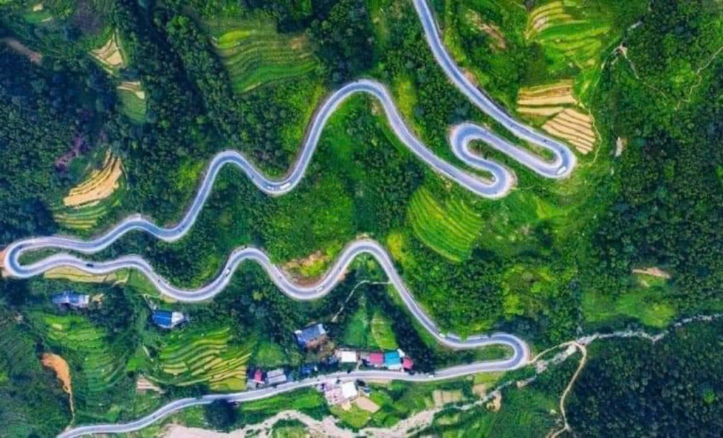
🛤️ THAM MA PASS – THE FAMOUS ZIGZAG ROAD OF HA GIANG 🏞️
Winding, zigzagging roads are one of Ha Giang’s most iconic features, weaving through towering mountains and terraced fields. 🌄🌾
Tham Ma Pass is a remarkable section of the legendary “Happiness Road”, a route built and safeguarded through the sacrifices of many generations before us. 🛤️❤️
At the summit of Tham Ma Pass, visitors will find a charming rest stop where local children dressed in vibrant traditional costumes warmly welcome travelers. 👧🧑🌈
Here, you can enjoy breathtaking panoramic views of the valley below and capture memorable photos with the friendly children, making your journey even more unforgettable. 📸✨

🚩 Lung Cu Flag Point – The Northernmost Tip of Vietnam
Located in Dong Van District, Ha Giang, the Lung Cu Flag Point proudly marks the northernmost point of Vietnam 🇻🇳. Built in 2010, this iconic site has become one of the must-visit landmarks for anyone exploring the majestic landscapes of Ha Giang.
To reach the top, visitors climb 389 stone steps leading to the base of the monument. At the summit, a massive 54m² Vietnamese national flag waves proudly in the sky—symbolizing the unbreakable spirit and unity of the Vietnamese people through thousands of years 🏞️❤️.
From this elevated viewpoint, you’ll be treated to panoramic views of the stunning Dong Van Karst Plateau, a UNESCO Global Geopark. The scenery is so awe-inspiring, it feels like a masterpiece crafted by nature itself 🌄🌿.
📍 Location: Lung Cu Commune, Dong Van, Ha Giang
📷 Best for: National pride, breathtaking views, bucket-list photos

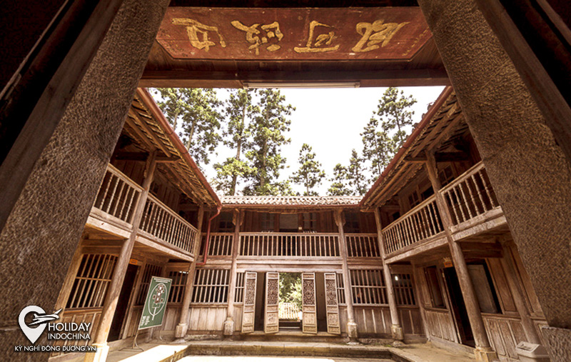
🏯 H’Mong Royal Palace – The Majestic Legacy of the Vuong Family
The H’Mong Royal Palace, also known as the Palace of the Vuong Family, is a must-visit historical site in Dong Van District, Ha Giang Province 🇻🇳. Once the grandest residence in the region, it was home to the wealthiest and most influential H’Mong family in northern Vietnam.
Built in the early 20th century, this remarkable palace showcases a unique blend of H’Mong, French, and Chinese architectural styles 🏛️—a rare fusion you won’t find anywhere else in the country. Its stone walls, wooden details, and intricate carvings reflect both cultural pride and historical richness.
Thanks to excellent preservation, the H’Mong Royal Palace remains in excellent condition and stands today as a top cultural attraction for travelers, especially the youth 🌏📸. A visit here offers deep insight into the region’s heritage and the fascinating story of the Vuong dynasty.
📍 Location: Sa Phin Valley, Dong Van, Ha Giang
🕰️ Best time to visit: September to November (for pleasant weather and stunning scenery)
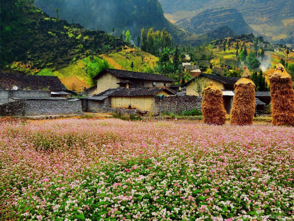
🏡 Lung Cam Cultural Village – A Timeless Gem of Dong Van
Nestled in the heart of Dong Van District, Ha Giang Province, Lung Cam Village is a charming cultural destination that preserves the authentic spirit of the northern highlands of Vietnam 🇻🇳.
Famed for its centuries-old stone houses, Lung Cam showcases traditional brown brick-tiled roofs and unique stone fences—built entirely without binders—that reflect the resilience and craftsmanship of the local people 🧱✨. These homes are not just beautiful; they are living museums preserving the rich cultural heritage of the H’Mong and other ethnic communities.
Visitors are enchanted by the peaceful atmosphere, the stunning mountain scenery ⛰️, and the chance to experience daily life rooted in deep tradition. Lung Cam is especially popular among photographers, cultural explorers, and those seeking an authentic experience off the beaten path 📸🎒.
📍 Location: Lung Cam Village, Dong Van District, Ha Giang
🌟 Highlights: Ancient stone houses, traditional crafts, scenic beauty
🌿 Suoi Thau Steppe – The “European Grassland” of Ha Giang
📍 Nestled in the western part of Ha Giang Province, Suoi Thau Steppe in Xin Man District is often referred to as the “European steppe” of Vietnam – a hidden gem that captivates visitors with its wild, rustic, and majestic beauty 🌾⛰️.
🌳 Covering an area of over 90 hectares, Suoi Thau is a vast, open grassland plateau surrounded by rolling hills and dotted with colorful wildflowers. Its landscape is unlike anywhere else in the region, making it a must-visit for nature lovers and photographers 📸🌼.
📍 Located just 5 km from Coc Pai Town, and perched at an altitude of over 1,200 meters above sea level, this highland meadow offers cool, fresh air and panoramic views that resemble European countryside scenes, especially during spring and autumn 🌤️🌸🍂.
✨ Whether you’re exploring by motorbike, trekking through the fields, or simply enjoying a peaceful escape in nature, Suoi Thau Steppe is one of the most unique and serene destinations in Northern Vietnam 🧭🌿.

🏘️ DONG VAN ANCIENT TOWN – WHERE TIME SEEMS TO STAND STILL IN HA GIANG ⏳🏔️
Nestled in Dong Van District, Dong Van Ancient Town feels like a place where the boundaries between past and present gently blur. 🕰️✨
With its hundreds of years-old houses, bustling highland markets, and vibrant festival nights, the town offers a unique glimpse into the rich cultural heritage of the northern highlands. 🎉🏠
Situated at an altitude ranging from 1,000 to 1,600 meters above sea level, Dong Van is embraced by rolling mountains and dense forests on all sides. 🌄🌲
This ancient town remains cloaked in a peaceful silence and timeless charm, inviting visitors to step back and experience the quiet beauty and history preserved through centuries. 🌿🌙

🏞️ Gio Pass – The Legendary Route of Ha Giang’s Stone Plateau
📍 Gio Pass is a dramatic and challenging mountain road located on Provincial Road 178, lying between Nam Dan and Na Chi Communes in Ha Giang Province. Known as one of the toughest passes on the majestic stone plateau, it offers both thrill and awe to adventurous travelers 🛣️🧗♂️.
⛰️ Despite its rugged terrain, Gio Pass captivates visitors with its untamed natural beauty and rich cultural significance. The surrounding landscape features dramatic cliffs, deep valleys, and panoramic views that reflect the raw essence of Northern Vietnam’s highlands 🌄🌿.
🏛️ In recognition of its scenic, cultural, and historical value, Gio Pass, along with the nearby ancient Nam Dan – Thac Tien – Deo Gio stone fields, was officially designated as a National Scenic Site by the Ministry of Culture, Sports and Tourism in 2009 🏞️📜.
✨ Whether you are a passionate motorbiker, nature explorer, or cultural traveler, Gio Pass promises a journey filled with unforgettable sights and the spirit of the highland frontier 🧭🌬️.

🗻 Ma Pi Leng Pass – The King of Northern Vietnam’s Mountain Roads
Known as one of the most breathtaking mountain passes in Vietnam, Ma Pi Leng Pass is a dream destination for adventurous travelers and motorbike riders alike 🇻🇳🏍️. Located in Ha Giang Province, this legendary route is part of the famous “Happiness Road” connecting Dong Van and Meo Vac.
With towering cliffs on one side and a deep abyss on the other, Ma Pi Leng offers a dramatic, heart-racing experience that every trekking or road-trip enthusiast longs to conquer ⛰️💨.
At the summit lies the Panorama Viewpoint, where you’ll be rewarded with jaw-dropping views of rugged limestone mountains, lush terraced fields, and the emerald waters of the Nho Que River winding through the majestic Tu San Canyon—the deepest canyon in Southeast Asia 🌄🌊.
📍 Location: Between Dong Van and Meo Vac, Ha Giang
🎯 Highlights: Epic views, Tu San Canyon, motorbike adventure
🪨 DEATH ROCK – THE LEGENDARY LANDMARK AT THE END OF GIO PASS 🏞️
Located at the end of Gio Pass, Death Rock is a must-visit spot on the famous Ma Pi Leng Pass route, nestled in Pai Lung Commune, Meo Vac District, Ha Giang Province. 🚗⛰️
This iconic site is well-known and beloved by backpackers for its breathtaking, majestic beauty and the thrilling challenges it presents to travelers. 🌄🔥
Death Rock offers awe-inspiring views that capture the rugged, wild spirit of Ha Giang’s mountainous landscape, making it an unforgettable highlight for any adventure seeker. 📸✨

🪨 WHITE CLIFFS – THE MAGICAL CLIFFS OF HA GIANG ✨
Located about 160 km from Ha Giang City, right along the famous Ma Pi Leng Pass, the Ha Giang White Stone Cliffs—also known as the Magic Cliffs—are just 2 km from Dong Van and Meo Vac. 🗺️⛰️
This spectacular site is famed for its dramatic, towering cliffs and is a thrilling destination for adventure lovers and explorers seeking a challenge. 🧗♂️⚡
With breathtaking views and a rugged terrain, the White Cliffs offer a unique experience that captures the wild beauty and spirit of Ha Giang’s northern highlands. 🌄🌿

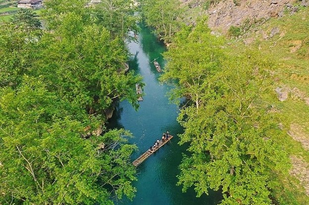
🌊 Nho Que River – The Emerald Ribbon of Ha Giang
Flowing gracefully through the rugged mountains of northeastern Vietnam, the Nho Que River is often described as a silken ribbon woven through the peaks of Ha Giang 🇻🇳. With its clear turquoise water and peaceful charm, the river captures the hearts of all who pass by Ma Pi Leng Pass.
The most stunning section of the river lies in the Tu San Canyon, Southeast Asia’s deepest gorge 🏞️. Here, travelers can hire a boat and glide along the narrow river channel, gently brushing the crystal-clear water and soaking in the surreal beauty around them 🚣♂️✨.
Framed by towering cliffs and an endless blue sky, this spot offers an unforgettable experience for anyone journeying along the Ha Giang Loop. It’s a place where nature’s power and elegance meet, leaving every visitor in awe.
📍 Location: Tu San Canyon, beneath Ma Pi Leng Pass
🌟 Experience: Boat tours, nature photography, riverside serenity

🏘️ Pa Vi Village – A Cultural Heartbeat of Meo Vac’s Rocky Plateau
Located in the stunning Meo Vac rocky region of Ha Giang, Pa Vi Ha Village stands out as a vibrant community-based cultural tourism destination 🇻🇳. This charming village is home to the Mong ethnic people, who have preserved their rich traditions and way of life for generations.
Covering more than 46,000 square meters, the village is thoughtfully organized into three main areas and is currently inhabited by 26 ethnic households 🏡👨👩👧👦. Visitors to Pa Vi can admire the unique architecture of traditional Mong houses, enjoy cultural performances, taste local cuisine, and immerse themselves in the everyday life of this welcoming community.
Pa Vi Village offers an authentic cultural experience, making it a meaningful stop along the Ha Giang Loop for those who wish to connect with the region’s deep-rooted heritage 🎎🥁.
📍 Location: Pa Vi Ha Village, Meo Vac District, Ha Giang
🌟 Highlights: Mong culture, traditional houses, community tourism
💧 Ban An Stream – A Hidden Gem in Ha Giang’s Wilderness
Tucked away in Ngoc Long Commune, Yen Minh District, Ban An Stream remains one of Ha Giang’s most untouched natural treasures 🇻🇳. Quiet and lesser-known, this serene spot feels like time has stood still, offering a peaceful retreat far from the tourist crowds.
Surrounded by lush greenery and gentle hills, the stream flows with refreshing, crystal-clear water, creating a cool and calming atmosphere 🌿💦. There’s a subtle melancholic charm to the landscape—perfect for those seeking a quiet moment of reflection or connection with nature.
Whether you’re a photographer, a nature lover, or simply in search of solitude, Ban An Stream offers a unique and soulful escape in the heart of northern Vietnam.
📍 Location: Ngoc Long Commune, Yen Minh District, Ha Giang
🌟 Ideal for: Peaceful retreats, hidden nature, off-the-beaten-path exploration
🏞️ Du Gia Town – A Peaceful Valley Hidden in Ha Giang
Unlike the well-known destinations of Dong Van or Meo Vac, Du Gia is a charming, lesser-known town nestled in a lush green valley of Yen Minh District, Ha Giang Province 🇻🇳. Its tranquil atmosphere and authentic local life make it a perfect stop on your Ha Giang Loop journey.
In Du Gia, you can visit a local daily market, where ethnic residents sell fresh farming products and handmade goods 🥬🧺. Along the roadside, you’ll often see women and children in colorful traditional clothes, joyfully chatting and warmly inviting travelers to explore their crafts and cuisine 🎨🧒.
Just outside the town lies the Du Gia National Park, a 15-hectare nature reserve rich in rare flora and fauna, ideal for nature walks, wildlife spotting, and eco-tourism 🌿🦋.
📍 Location: Du Gia Town, Yen Minh District, Ha Giang
🌟 Highlights: Local markets, ethnic culture, Du Gia National Park
📍 Viet Quang – Gateway to Southern Ha Giang
Viet Quang is a district-level town located in the southern part of Ha Giang Province, approximately 60 km north of Ha Giang City and about 210 km from central Hanoi 🇻🇳.

🌿 Thong Nguyen Village – The Land of Harmony in Hoang Su Phi
Situated on the left bank where three major streams—Phin Ho, Nam Ong, and Nam Khoa—converge, Thong Nguyen Village forms a unique plateau nestled halfway up the mountain in Hoang Su Phi District, Ha Giang 🇻🇳.
This natural convergence creates fertile soil enriched by annual alluvial deposits, earning Thong Nguyen the reputation of “Quan Son – Tu Thuy”—a land blessed with “Heavenly Time, Earthly Benefits, and Human Harmony” 🌏🌱🤝. Ancient locals regarded this area as an “open land” full of promise and bright prospects, symbolizing hope and prosperity for generations.
Visiting Thong Nguyen offers a glimpse into the harmonious relationship between nature and human life, making it a meaningful cultural and ecological destination in Ha Giang.
📍 Location: Thong Nguyen Commune, Hoang Su Phi District, Ha Giang
🌟 Highlights: Fertile plateau, cultural harmony, scenic waterways

🌾 Explore Nam Ty Commune – Hidden Gem of Hoang Su Phi,
📍 Nam Ty is oneHoang, nestled inHa Giang P,45.30 km², Nam Ty iterraced that
👨👩👧 With a population of just 2,857 (asoff-the-beaten-path expe,
📌 Located in the sou ofnortheastern Vietnam, making itconveni on y
✨ Whether you’re a nature lover, photographer, or cultural explorer, Nam Ty Commune pr

🌊 Discover Ho Thau Commune – Where the Rivers Begin
📍 Ho Thau Commune is affectionately known by locals as “Dầu Nguồn”, which means “the source” in the local language. This name reflects its unique location as the origin of two important rivers in Northern Vietnam – the Chay River and the Bac River 🌄💧.
🌿 Located in the southern part of Hoang Su Phi District, Ho Thau is approximately 30 km from the district center, making it an easily accessible destination for those looking to explore Ha Giang’s untouched natural beauty 🗺️🚗.
🏞️ Surrounded by majestic mountains, lush forests, and clear flowing streams, Ho Thau offers travelers a serene retreat and an authentic glimpse into the culture and life of ethnic minorities living in the region 🧭🏕️.
✨ Whether you’re trekking through the mountains, exploring river sources, or immersing yourself in local traditions, Ho Thau Commune is a must-visit destination for nature lovers and adventure seekers alike 🌲⛰️.

🌾 Luoc village Commune – The Heart of Hoang Su Phi’s Terraced Rice Fields
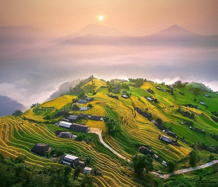
📍 Ban Luoc Commune is located in the core area of the Hoang Su Phi National Scenic Area, famed for its breathtaking terraced rice fields. It proudly boasts the largest area of silver terraced fields in Vietnam, covering approximately 200 hectares 🌿🌄.
🌾 These magnificent terraces stretch in multi-layered patterns from the stream banks all the way up to the mountaintops, lying entirely on the northern slope of Chieu Lau Thi Mountain. The scene is especially stunning during the rice season when the fields shimmer like mirrors under the sun 🌞🌾.
🏡 As you journey to Ban Luoc, you’ll encounter charming traditional wooden houses and stilt houses of the Dao and Tay ethnic communities, nestled gracefully halfway up the mountain ⛰️🏘️.
🌲 The deeper you venture into the villages, the more you’re surrounded by the raw, majestic beauty of Ban Luoc’s natural landscape. It’s a destination that offers both cultural richness and unforgettable scenery for photographers, trekkers, and nature enthusiasts alike 📸🧭.

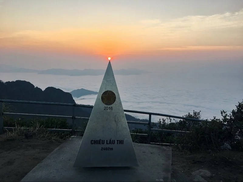
☁️ Chieu Lau Thi – The Legendary “Stairway to the Clouds” in Ha Giang
📍 Chieu Lau Thi, also known as Kieu Lieu Ti, is a stunning cloud-hunting and trekking destination located about 130 km from Ha Giang City 🚗🌄. Nestled in Tan Minh and Chien Thang villages of Ho Thau Commune, Hoang Su Phi District, this majestic mountain attracts travelers year-round, as each season reveals a unique and mesmerizing beauty 🌿❄️🌸🌞.
⛰️ The name “Chieu Lau Thi” comes from the Chinese language — “Chieu Lau” means nine steps, and “Thi” means a large, towering rock. Put together, it poetically translates to “Nine Floors of Stairs“, perfectly describing the mountain’s layered, mystical appearance as it reaches into the clouds 🪜☁️.
🏔️ Standing tall at 2,402 meters, Chieu Lau Thi is the second-highest peak in Ha Giang Province, located in the rugged Tay Con Linh mountain range. It’s a paradise for trekkers, photographers, and adventure lovers looking to conquer the highlands and witness breathtaking panoramic views from above the clouds 🌤️📸.
✨ Whether you’re chasing the sunrise, immersed in the mist, or stargazing at night, Chieu Lau Thi offers an unforgettable journey into the heart of Ha Giang’s highland wilderness 🌌🧭.
🌾 Phung Village – The Terraced Rice Paradise of Hoang Su Phi
📍 Phung Village, often called Phung Vision, is a breathtaking destination and the symbolic heart of Hoang Su Phi, renowned for its world-famous terraced rice fields 🌿⛰️.
🌾 This picturesque village is truly a terraced rice paradise, where nature and tradition blend in perfect harmony. To visit Hoang Su Phi and miss Phung Village would be to overlook one of the region’s greatest treasures 💎🗺️.
🏡 From above, the golden rice terraces cascade gracefully down the mountains, embracing the cozy rooftops of local ethnic homes. The landscape here is both majestic and tranquil, creating a scene that is powerful yet peaceful — a true photographer’s dream 📸✨.
🌤️ Whether you’re hiking, exploring local culture, or simply soaking in the views, Phung Village promises a soul-stirring experience that captures the essence of Northern Vietnam’s natural and cultural beauty.
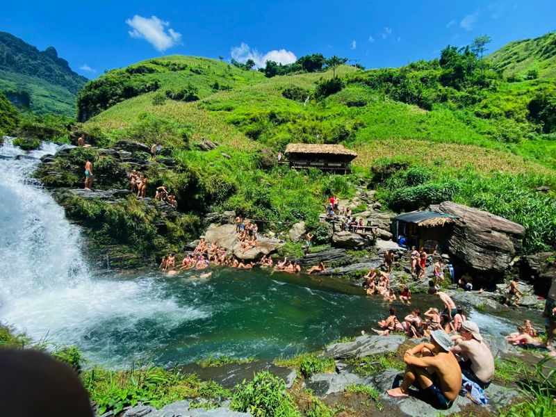
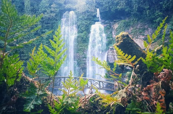
💦 Tien Waterfall – A Hidden Gem in the Heart of Xin Man, Ha Giang
📍 Located in the remote wilderness of Nam Dan Commune, Tien Waterfall is one of the most breathtaking natural attractions in Xin Man District, Ha Giang Province. To reach this enchanting site, visitors must travel around 17 km from the center of Coc Pai Town 🚗🌄.
🌿 Tien Waterfall lies deep within the Gio Pass primeval forest, offering an unforgettable journey through untouched nature. After about 10 km of winding downhill trails, you’ll find yourself immersed in a pristine world of rare flora and ancient greenery 🌳🌸.
🍄 The forest surrounding the waterfall is home to a rich ecosystem, including wild orchids, medicinal herbs, exotic mushrooms, and many species of precious hardwood trees believed to be thousands of years old 🌱🌲.
🌊 As you arrive, the sound of cascading water blends with the tranquil forest, creating a peaceful retreat far from the hustle of daily life. Tien Waterfall is a true hidden treasure — perfect for trekkers, nature lovers, and eco-tourists seeking to experience the raw beauty of Northern Vietnam 🌏🧭.
Ha Giang Loop
📲 Follow Us for More Travel Inspiration!
🔹Page Facebook: Time Travel
🔹 Facebook: Tuan Dao
🔹 Instagram: @timetravel.trips
🔹 YouTube: Time Travel
🔹 TikTok: timetravelhagiangloop
🔹linkedin: Tuan Dao
🔥 Join us for an unforgettable journey through Ha Giang! 🌿🏍️💨
To book a tour you can call or text me via whatsapp: +84978898178 – +84888815283
appointment
book tickets
Hà Giang Loop by Bus – The Ultimate 3-Day Adventure
🚌 Ha Giang Loop by Bus – Safe & Scenic for All Ages 👨👩👧👦🌄 Can’t ride a motorbike? No problem! Discover the full Ha Giang Loop in 3 days by VIP bus – safe, comfortable, and perfect for families, seniors, and kids. ✅ All highlights, local guide, great food, and no stress!
$46.00
Contact us
Welcome to a world of limitless possibilities, where the journey is as exhilarating as the destination, and where every moment is an opportunity to make your mark on the canvas of existence. The only limit is the extent of your imagination.
Thank you for your response. ✨

Link one
Link two
Link three
Link four

Leave a comment